Things for Unit 5 you should UNDERSTAND, KNOW, and be able to DO...
Understand:
- Landforms are the result of the interaction of tectonic forces and the processes of weathering, erosion, and deposition.
Know:
- Natural agents of erosion, generally driven by gravity, remove, transport, and deposit weathered rock particles.
- The natural agents of erosion include: streams, glaciers, wave action, wind, and mass movement.
- Streams (running water):
- Gradient, discharge, and channel shape influence a stream’s velocity and the erosion and deposition of sediments.
- As discharge or gradient increase, velocity increases.
- Sediments transported by streams tend to become rounded as a result of abrasion.
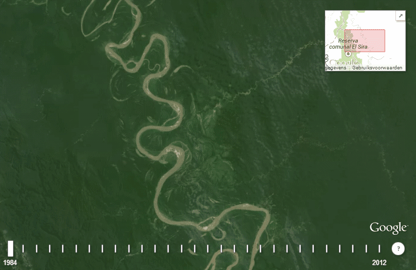
- Stream features include V-shaped valleys, deltas, flood plains, and meanders.
- A watershed (drainage basin) is the area drained by a stream and its tributaries.
- The underlying bedrock determines the stream drainage patterns
- Friction between the water and the stream bed and air causes water to slow down
- In a straight channel, water moves the fastest near the center of the stream just below the surface.
- In a meandering river water moves the fastest in the outside bend (cut bank)
- The inside bend of a meandering river (point bar) is dominated by deposition
- The outside bend of a meandering river (cut bank) is dominated by erosion
- As the velocity of a river decreases, sediments are deposited. Further, rivers sort sediments.
- Glaciers (moving ice):
- Glaciers form when snow compacts to form ice (firn) on land at either high latitude or elevation and moves under the influence of gravity.
- Glacial erosional processes include the formation of U-shaped valleys, parallel scratches, and grooves in bedrock.
- Glacial features include moraines, drumlins, kettle lakes, finger lakes, erratics, and outwash plains.
- Drumlins and glacial striations allow geologists to determine the direction glaciers were moving.
- Sediments deposited by glaciers are unsorted (glacial till).
- Most of New York State was covered with glacial ice during the last ice age (Pleistocene Glaciation) which modified the landscape.
- Wave action:
- Erosion and deposition cause changes in shoreline features, including beaches, sandbars, and barrier islands.
- Wave action rounds sediments as a result of abrasion.
- Waves approaching a shoreline at an angle move sand parallel to the shore within the zone of breaking waves (longshore transport/drift).
- Wind:
- Erosion of sediments by wind is most common in arid climates and along shorelines.
- Wind-generated features include dunes and sand-blasted bedrock.
- Wind direction may be determined by the shape of a sand dune. (The gentle sloping side indicates the wind direction.)
- Mass movement:
- Earth materials move downslope under the influence of gravity.
- Patterns of deposition result from a loss of energy within the transporting system and are influenced by the size, shape and density of the transported particles.
- Sediments deposits may be sorted or unsorted.
- Each agent of erosion produces distinctive changes in the material that it transports and creates characteristic surface features and landscapes.
- Climate variations, structure, and characteristics of bedrock influence the developments of landscape features including mountains, plateaus, plains, valleys, ridges, escarpments, and stream drainage patterns.
- Landscapes:
- There are three types of landscape (Mountain, Plateau, and Plain or Lowland).
- Landscapes are classified based upon their relief and underlying bedrock.
- Mountains have the greatest amount of relief and are underlain by igneous or metamorphic bedrock.
- Plateaus have a moderate amount of relief and are underlain by horizontal sedimentary bedrock.
- Plains or Lowlands have the least amount of relief and are underlain by horizontal sedimentary bedrock.
- Landscapes that develop in humid climates tend to be more rounded then landscapes that develop in more arid climates.
Vocab Terms: arid, delta, deposition, discharge, drumlin, erratic, esker, flood plain, glacier, gradient, gravity, horizontal sorting, humid, kettle, landscape, landslide, longshore drift, meanders, moraine, plateau, sandbar, sorted, striations, till, unsorted, U-shaped valley, velocity, vertical sorting, watershed, solution, suspension, bed load, cut bank, point bar, V-shaped valley, sand dune, mountain, plateau, plain, lowland.
Extended Vocabulary: alpine glacier, arête, bed load, cirque, creep, drainage pattern, horn, levees, outwash plain, oxbow lake, slump, turbidity, barrier island, talus, sand bar
Do:
- Calculate stream gradient.
- Determine how gradient and discharge affect stream velocity.
- Determine how a streams velocity affects the erosion and deposition of sediment.
- Use the ESRT to determine the relationship of transported particle size to water velocity.
- Determine how size, shape, and density affect the settling rate of sediments.

